 Live Music Archive
 Librivox Free Audio
 Metropolitan Museum
 Cleveland Museum of Art
 Internet Arcade
 Console Living Room
 Books to Borrow
 Open Library
 TV News
 Understanding 9/11
tv ABC2 News at 6PM ABC October 29, 2012 6:00pm-6:30pm EDT
6:00 pm
part of it remains for the next hour or two. it could strengthen slightly before it weakens. it still has that tap into the gulf stream. just to give you a little different perspective on the size and scope had will reach into the upper midwest, flooding off the great lakes. this is a massive, massive storm. as we look at the next three days, cyclone conditions continuing, extremely gusty tomorrow. when will the worst of it be, from now until 6 tomorrow morning. it will be rough. >> okay. abc2 news at 6 starts right now. all right. welcoming hurricane sandy
6:01 pm

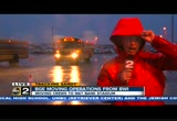
coverage. we'll be here for the rest of the night. >> definitely, as the storm moves ashore. let's check in with abc2 news brian kuebler. he is at mema headquarters. brian? >> reporter: hey, kelly, how are you? we're waiting on the governor and will talk to him in a few minutes and do a one-on-one interview. we'll have new information for you from the governor. from the last briefing he said sandy is coming quicker. a few bridges have been closed, tydings, 95, the big interstate that runs through the state is close to being closed. i ran outside real quick.
6:02 pm

the wind gusts, the wind is coming quickly. tomorrow -- pushing forward to tomorrow, mta metro closed, buses, light rail, everything closed tomorrow. state government is closed and there will be no early voting again for the third straight day tomorrow. they said they will make those hours up coming up soon. they have to figure out how they will do that. so far right now about 75,000 people without power. the governor should have more information at 9:30. again, in a few minutes we'll join you with a one-on-one interview with the governor and other details that have popped up in the past hour. >> you said you had information? >> listen to this, brian.
6:03 pm

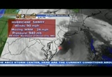
okay. he's gone. she runs a great business in baltimore. she's in florence, italy and watching our storm coverage. she's in a hotel room, keeping posted on what's going on. so we are monitoring everybody that's talking to us on facebook and twitter, abc2news.com, so get onboard. we'll go to meteorologist wyatt everhart with a look at sandy. all right. let's give you the full breakdown on hurricane sandy, still a powerful border line category 2 hurricane. we knew we would maintain strength and perhaps see intensification with the storm. we were a little surprised when we saw this ramp up to 90 miles per hour and prsh down --
6:04 pm

pressure down to 940. this puts it at a category two. this unusual super storm. it has in the just taken that hard turn into the states like agnes did, farther north, but the fact this has been strengthening as it comes ashore. we are used to seeing hurricanes weaken as we enter the northern waters, especially am late october. in this situation we have a warm section courtesy of the gulf stream current. we've had almost no shear. unbelievable. winds now sustained near 50. crisfield with reports of significant damage and flooding here at the mouth of the chesapeake. winds have been hard northwest. that, for the first day will help to drain the chesapeake. by tomorrow sandy will reposition. we could see winds turning
6:05 pm
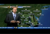
south, southwesterly. we have high tide circles tonight but especially tomorrow when the winds will not be hard. updated wind gusts 86 in crisfield. 62 kent island. now you know why we had an extremely rare hurricane force wind warning and pope thngsly experience hurricane force winds -- potentially experiencing hurricane force winds, a bit of a scary event. we'll get through this through the night and we'll see the storm relent so. wednesday we'll look for the big improvement. for now we're dealing with it. big flooding on the oat heat beaches through early this morning. now has we push toward the
6:06 pm

evening hours we begin to bring in our next high tide cycle. we're already seeing those water come up further. we've had huge erosion. in you look carefully, that's sand on the boardwalk. we had the boardwalk overflow. in rehoboth big storm surge expected to come. kent island, you can see here. i'll step out of the shot and try to find the bay bridge in that shot. you would not want to drive a low profile vehicle over it. we're seeing it all in maryland. the snow starting to come down. it's been coming down in deep creek. that snow line is creeping furtheo the east. we'll he plenty of rain and wind. again, the big rain still coming down. flood warnings still statewide. irene we got over 10 rough result the coastal concerns will be not just tonight, on the
6:07 pm
eastern shore. the chesapeake bay flooding will continue tomorrow as winds will turn southwest and tomorrow we'll be watching the bay carefully, too. back to you. >> boy, joce sterman out at bwi got a taste of the storm. look that the that. >> reporter: things have really picked up here at bwi, the bge staging headquarters. they are wrapping things up. because of the the dwindling, deteriorating conditions at this point, they will take the workers that are left and bust them out to area hotels. each one is designated to go to a different hotel. at this point the staging hear
6:08 pm
for bge has become -- area for bge has become very, very minimally active. the rest of them -- the most of them have moved on to other locations as the wind intensifies quite a bit. they are planning at this point to shut down all four staging areas when they think the weather will be better. they have these four locations scattered around the baltimore area. they're dealing with as many as 4,000 crew meme bers from insta -- members from instate and out of state. they're helping with power restoration. we are nowhere near that point but they are gearing up anyway. they have the bucket trucks. they want to keep them well fed and rested. we are at this point just watching the situation just like everybody else and keeping up with the bge cruise -- crews.
6:09 pm
we spoke with a theme that came from chicago. they're mission out on family events. they said they've done this every year. almost every major holiday they have miss bid traveling to some other region of the country to help deal with some sort of disaster. so that's the situation. they're wrapping up at bwi and will return first thing tomorrow morning. live at bwi, joce sterman, abc2 news. >> all right. brian keebler live at mea -- mema with the governor. >> reporter: governor, what is your main concern. you said sandy who get tougher, stronger, quicker. >> we had people who were surprised by the tidal surge in the chesapeake and crisfield is
6:10 pm

now being evacuated. that's 150 people. we had our first report of a fatality, traffic related in montgomery county, the first fatality of this storm. we'll be seeing probably the highest waves coming up over ocean city that will happen about 8:30 tonight. there's a lot of tricky dynamics at play and all of them threatening the lives of our state. >> eight to 10 will make landfall and 8:25 the high tide. >> there's a full moon and all the other things as well. the storm is moving faster. so hopefully she will get heck out of maryland sooner than we anticipated. the earlier reports indicate she might sit on top of us and beat on us for an extbded p-p--- extended period of time.
6:11 pm

this will be a long night with a lot of snaps and breaking of big trees. people need to take precautions and stay indoors. >> a lot of big bridges, thoroughfares being closed. is the tydings bridge closed. the tydings bridge -- i don't believe the tydings bridge has been closed. that's our last link to the shore. the hatem has been closed much the route 90 bridge over the bay at ocean city. that has been closed. and what else. the key bridge has been closed and the bay bridge has been closed. there are wind advisories on the thomas johnson, the harry nice bridge and the tydings bridge. >> no state government tomorrow, no early voting. >> no state government, no early voting, no bus service, light rail, nothing. this will be beating us up until at least the afternoon tomorrow. my hope is before -- my hope is
6:12 pm

we're able to get some utility crews out there. my hope is the wind will die down so we can start doing power restorations. that number is going to climb. >> okay, thank you, governor. straight from the governor's mouth. we'll have more information tonight at 9:30 at his next briefing and will join you then as well. >> thank you for that live report. now we'll check in with abc2's christian schaffer. >> we're waiting for the storm surge to come. now that sandy has moved up the coast, the one noticeable change that we see here in rehoboth is the waves have gotten massive. it's been raining all day. the waves behind me have been gyp gan tick, 3 -- gigantic, 30
6:13 pm

feet in the air. that's the main concern is that tidal surge coming in. we're a couple hours before high tide. the waves have gotten e nor movements people have been coming out to look at them. a short time ago the governor of delaware was here. take a look. okay. well it looks like we didn't have that sound byte. he had been with them on a tour. rehoboth is pretty much okay. it hasn't seen that large coastal surge. but dewey beach is between the
6:14 pm

bay and the ocean, those are connected at this point. the water has overtaken dewey bee. the coastal highway has been closed since sunday between due whip and bethany where it goes over the inlet that has been closed and it's continuing to get worse as the narrow areas start to meet. here in rehoboth what they're looking for is it appears to be coming in. we'll keep an eye on that we're live in rehoboth beach, christian schaffer, abc2 news. all right. following the storm up there in rehoboth, atlantic city boardwalk. you ve this go online. the eater -- water is overtaking the boardwalk. let's go outside now.
6:15 pm

jeff hager is outside. an area that kno flooding very well. let's see how the folks are preparing. >> reporter: earlier today we were along the chesapeake bay. we touched basin millers eye land even though they went through the bankrupt of it, they're seeing things they've never seen b sandwiched between the back river and chesapeake barks the millers island community may be one of the most exposed neighborhoods to surging water. >> we had a shore house right there that we're more concerned about because it's lower and on the water, but i think weir hear okay -- we're okay here. >> reporter: what do you do, hunker down? >> hunker down. >> reporter: many of the residents had to rebuild after us is a bell nine years ago.
6:16 pm

>> all the vehicles are gone. we've moved all the deck furniture, as you can see. the boat's out of the water. if we get a surge, we're prepared for it. >> reporter: north area -- the dave brothers aren't about to shelter in plashings for fear they might get stranded. >> we're going to whitewash. worried about trees coming down. >> reporter: the volunteer fire department has been monitoring conditions and also learned a lesson from us is a belt they note storm surge can into the homes. now they're prepared for almost anything. >> there's been so many forecasts that we're being prepared. crews are fully staffed. resources available to us.
6:17 pm

all we have to do is make the phone call into mema . >> reporter: while me have accepted the fate, those too young to remember the past are embracing the moment do you like storms? >> yes. >> reporter: how come? >> because we do have school. >> reporter: if it keeps up like this, they won't have school again tomorrow. many people there who dealt with isabelle in 2003 lost everything. they lost their homes. many were condemned. a lot of tougher restrictions came in. they to build higher. they are better prepared. also today we notice in both of those water side communities, a lot of police presence because there were some looting issues back during us is a left even though water was starting to cross the road, they were making sure everyone's property would
6:18 pm

stay as safe as possible throughout the storm. jeff hager, back to you. >> look behind you. look at all the people on the roads. we keep hearing from the governor to get off the roads. where are these people going? >> reporter: even though the tydings bridge is closed, we saw all kinds of traffic. i have a feeling up and down the east coast, maybe people don't know which bridges are open, which are closed. we had peernlings 75 -- people going 75 miles per hour. there are people in a hurry to go nowhere but everyone should take top priority. >> if they've been through isabelle, they should know to take this seriously. >> reporter: it's primarily surge when you're on the bai. even though the winds are strong, those houses are built
6:19 pm

to last. they're more worried about getting a lot of the things that could float off, things that could be loose. now those people are a good 10 to 12 feet up. even with the big surge i don't think they're necessarily concerned about it getting to their property. >> thank you for the live report into we've got five people just text me who said the power's out. >> we'll be right back after the break.
6:20 pm

it's oysternomics 101. you start with a u.s. senator named ben. by helping restore thousands of acres of oyster beds, he kept hundreds of oystermen on the job... which keeps wholesalers in business... and that means more delivery companies... making deliveries to more restaurants... which hire more workers. and that means more oystermen. it's like he's out here with us. he's my friend, ben. i hope he's your friend, too. i'm ben cardin, and i approved this message. mayor: casino owners in west virginia are spending millions against question seven. that upsets me. and that upsets jonathan ogden. you don't want to upset jonathan ogden. ogden: no you don't. mayor: question seven means thousands of jobs and millions for our schools. but these west virginia casinos want to keep it all for themselves. we're not happy about that. ogden: no we aren't. mayor: so join us and vote for question seven. and west virginia, don't make me send jonathan ogden over there. mayor: vote for question seven. ogden: for baltimore.

6:22 pm

we are continuing to cover hurricane sandy. we're starting to experience the storm, the winds, the rains, the
6:23 pm

whole nastiness. >> this guy is not nasty. he's meteorologist mike masco. all right. here's what's going on, 90-mile-an-hour storms. so do we have the storm coming ashore around cape may county, big winds up and down the jersey shore. this is sliding through the delaware bay many we mr. see a push of major wind and rain during the course of the evening. west, now. central pressure at historic levels at 940. this is to the north of ocean city. this is coming ashore bringing all the winds and the rain. we have a hurricane hunter plane. we'll give you an advisory at 7:00. look at our surface winds. 96. you go to the south end of this
6:24 pm

still hurricane force winds being picked up. so just an impressive looking stat map we have for you. so showing tremendous winds coming into play. here's maryland's most powerful radar showing the bands. it's a moderate band charged up across 95. notice how this is moving and pivoting into queen anne's, cecil county. this pushes into anne arundel county, prince george's county and all of harford county. le' get a tremendous amount of rain and wind. winds will pick up. you'll get a quick wind gust perhaps close to 70. hurricane force winds. elkton, cecil county, into whitemarsh getting rked. you see that band from chest ortown to -- chester town to denton. the center is right near
6:25 pm
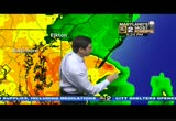
somewhere. it's a broad center. we're trying to pinpoint where it has gone. we're moving the visible satellite imagery. the band of tremendous winds and rain. follow the path of that. this will take it through delaware. we'll address this into cecil county, havre de grace. so we have hurricane force winds off the coast. we have blizzard like conditions from one extreme to the other. deep creek reporting snow into the foot lills ofno carrieráári0
6:26 pm

the winds have been incredible, knocking down trees and causing problems. it has blocked route 40 year joppa farm road. what happened was the state crews came out quickly and cut it down in order to row open the road. folks will be out -- there's a lot of driving rain. it has been causing problems throughout the area. a lot of people have been heeding that advice.
6:27 pm

once again, as the winds pick up, as the conditions change -- i thought i heard mike say that storm has come in off the -- has come ashore. one of the things you need to do, you need to make sure that you are off the roads. let mow toss it back to you -- me toss it back to you guys. jamie, kelly? >> just an indication of how tough the environment is. bge is asking people for patience. the winds are still strong and it will take awhile to restore. >> let's puts it to you this way. we will be on for the rest of the night. we'll be on for the rest of the overnight. this is historic, a matter of your safety. to find your regular programming. >> we have a list of your family show's. vernal 463, come exaft --
6:28 pm

comcast and direc-tv 2-2 our subchannels. those are the places to go. >> we'll put this on the crawl. >> we'll talk up until the first block of diane sawyer. we'll have her tell what the national outlook is and we'll come right back. >> this is a storm affecting over 60 million people. >> can i get an estimate how much time, ballpark time? >> about two minutes. >> this is amazing. it's kind of, you see it's pivoting around. this will probably come south to north, you know. >> so much information. it's unbelievable. a couple things, first off, the center will be crossing over northern delaware and northern baltimore county. we're going to have a period up to hurricane force winds from
6:29 pm

now until 6 a.m. so we're far from done. technically we're having landfall occur, don't read much into that. that's not all that critical. one other thing eight to 12 inches of rain. we had about half of that. we're on our way to a foot of rain. if there's any silver lining, the direction on the rain bands, that will help drain the bay and create a blow outside tide for today and tomorrow the winds will not be due north. there's a better chance tomorrow and we'll continue to see those blizzard conditions out in the western part of the state. so there are the winds, 70, 80, 60, power lines going down. we'll be with you all night. >> the governor will have a press
141 Views
IN COLLECTIONS
WMAR (ABC) Television Archive
  Television Archive News Search Service
Uploaded by TV Archive on
